
Warehouse logistics can take on various levels of complexity, but it cannot ignore certain fundamental concepts. One of these is undoubtedly the concept of the location. In fact, even the most complex and elaborate logistics continue to rely on a core element: the ability to distinguish the position of goods in order to analyze and optimize material flows.
To optimize operators’ time and tasks, from picking to put-away, companies must equip themselves with software capable of performing warehouse mapping. We are talking about WMS (Warehouse Management Systems) like silwa, a solution that allows for the creation of an extremely detailed spatial warehouse map, considering areas, racks, columns, levels, individual locations, and even slots. This provides a comprehensive overview of the warehouse, ensures compliance with the weight limits of individual racking systems, and, above all, guides operators by accounting for the specific requirements of picking or storing goods, such as the need to use forklifts to reach high-density storage areas. But how exactly does a warehouse map work, and which operations does it concretely optimize? We discussed this with Alessandro Riccio, Software Developer at Stesi.
What is a Warehouse Map?
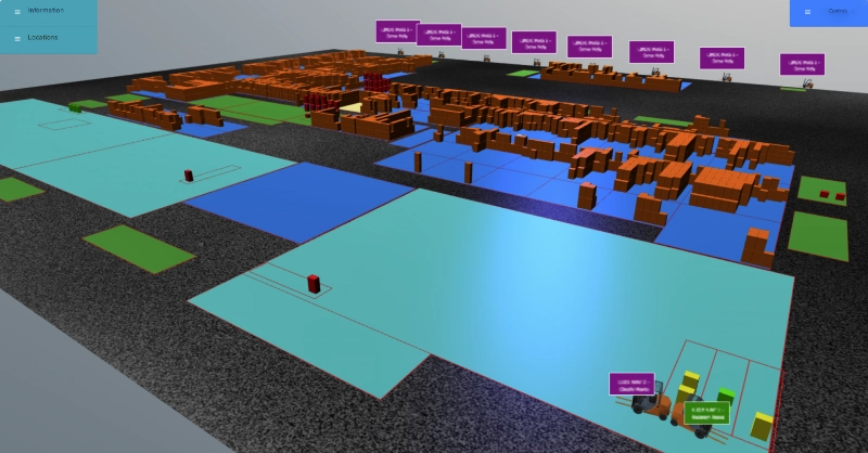
A warehouse map is the result of encoding all the physical locations within a warehouse into a software system. Simply put, the map is a graphical representation of the available storage space, encompassing properties such as dimensions, coordinates, height, relationships with other locations, and any other specific characteristics, in addition to the assignment of unique names.
When executed comprehensively and accurately, warehouse mapping positively impacts every stage of the logistical process: from inventory auditing, which requires statistical data on stock distribution, to the management of inbound and outbound goods, which necessitates dedicated staging areas.
What to include in an effective Warehouse Map (and the benefits)
What are the concrete characteristics that can be mapped? “An effective warehouse mapping,” says Alessandro Riccio, “takes into account two key aspects: the location name and its type. However, it becomes even more functional when it includes properties such as dimensions, maximum weight capacity, and distance from a so-called zero point.”
The Location Name
Regarding the names of individual locations identified during the mapping phase, it is useful to know that the primary name (e.g., “AreaB.Rack1.Col1.Lev3”) is essentially a unique alphanumeric code, actings as the location’s “ID card.” The name is easy for the operator to read and is self-explanatory, meaning it clearly indicates the physical position.
The Location Type
“Defining the purpose of an area (the location type) is crucial for developing operational flows,” says Alessandro. To better understand this necessity, consider some typical warehouse operations:
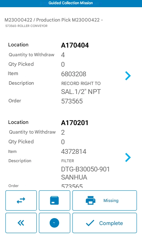
- Replenishment: moving goods from less accessible locations, known as “reserve stock,” to locations where picking operations can be performed quickly. A WMS software like silwa allows for the proactive scheduling of replenishment, optimizing the time and labor involved.
- Production feeding: moving goods toward production areas, which must contain only the stock required for immediate use.
- Inbound goods: incoming merchandise, arriving via truck or other means, is deposited in a dedicated staging or transit area which, unlike other locations, is always intended to be cleared quickly.
By knowing all these details, the software is able to guide operators effectively by determining which tasks are required.
Dimensions and Maximum Weight
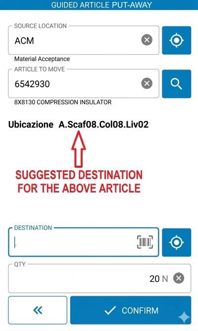
When it comes to completing put-away operations, knowing the available storage space is obviously fundamental. Some goods may be too large or too heavy for certain locations. Since the weight and dimensions of items are known to the software, understanding the physical constraints of the locations allows the system to direct the operator to other racks when necessary, eliminating any doubt during the storage process.
Coordinates Relative to a Zero Point
Thanks to the warehouse map, it is possible to know the relative position of all locations to the centimeter (both horizontally and vertically) and thus automate various calculations to optimize the operator’s work:
- Picking Path: the path is defined by the software itself based on the real-time position of the goods. This means that optimizing travel time within the warehouse no longer depends on the experience and tribal knowledge of the operators; instead, the software ensures everyone can move efficiently from day one.
- Finding the Right Location: the warehouse map makes it easy for the operator to identify the correct location for put-away based on the incoming material. In this way, similar products are easily consolidated within the same zone.

Warehouse Map with silwa
The silwa solution is designed to integrate all these data points, among many others. From the early stages of a project, Stesi works with the client to identify all the information to be implemented in the map, including flows and the level of detail required for each area.
“The goal is to allow customers to save valuable time, achieve higher efficiency, and reduce operational effort,” says Alessandro Riccio. This is why every business may require a different level of detail. With silwa, it is possible to move from macro to micro; in the case of a column rack, for example, one can consider the entire unit as a single location or proceed with a level of detail that makes every square meter an independent location. Clearly, the higher the level of detail, the easier it becomes for the operator to identify the correct location and be guided during picking or put-away tasks.
In the case of Aermec (whose main contractor is Toyota Material Handling Italia), the warehouse map created with silwa optimizes daily operations such as:
- Sales Order Picking: the software provides a pick-list in an order that minimizes the travel distance for operators (and, consequently, time and effort).
- Inbound Put-away and Stocking: mapping reduces product dispersion and prevents storage in locations incompatible with the product’s weight or dimensions. Without such a solution, operators would spend significant time physically searching for the right spot to store or consolidate new stock.
A different but similarly successful experience is that of Eurocarta, a direct Stesi client. By knowing the position of locations to the millimeter and implementing forklift localization, the system allows them to:
- Guide the Operator: providing detailed information on the location to be reached for pallet pickup/drop-off, and preventing the operation from proceeding if the forklift is not physically in front of the correct location.
- Automatic Scanning: “shooting” item barcodes directly from the forklift. Knowing which location the forklift is in front of, silwa can automatically proceed with the put-away/pick task.
- Facilitate Unplanned Tasks: when an operator needs to perform a manual move, silwa provides support. To “drop” a previously picked pallet, the operator simply presses a button: the system senses the fork’s location and automatically records the destination of the movement.
Want to learn more about warehouse mapping or the features of the silwa suite? Contact us.