

The RTLS (Real Time Location System) refers to a family of technologies that enable the real-time tracking of the position of objects, people, vehicles, and load units within environments such as warehouses, plants, and logistics hubs.
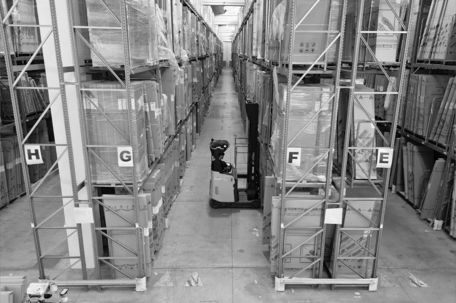
Anyone who manages a warehouse on a daily basis has likely experienced situations such as an urgent package being shipped late because nobody knew where it was, two forklifts ending up in the same aisle and slowing down operations, or difficulties reconstructing what happened after a shipping error. All of this happens because there is no real-time visibility of what is moving, where it is, and in what conditions. RTLS systems were developed precisely to address these issues. More advanced systems also integrate IoT sensors to monitor environmental conditions as well (e.g. temperature, tag battery status).
Developed between the 1980s and 1990s, RTLS solutions are now advanced technologies for companies seeking to optimize operational efficiency, safety, and warehouse flow management. Thanks to its integration with systems such as WMS software, RTLS enables automated tracking, error reduction, and productivity gains. RTLS systems make geolocation inside logistics facilities possible and have become a true must-have for companies that want to fully leverage digitalization and eliminate the blind spots typical of traditional logistics.
RTLS technology: how it works and what needs it addresses
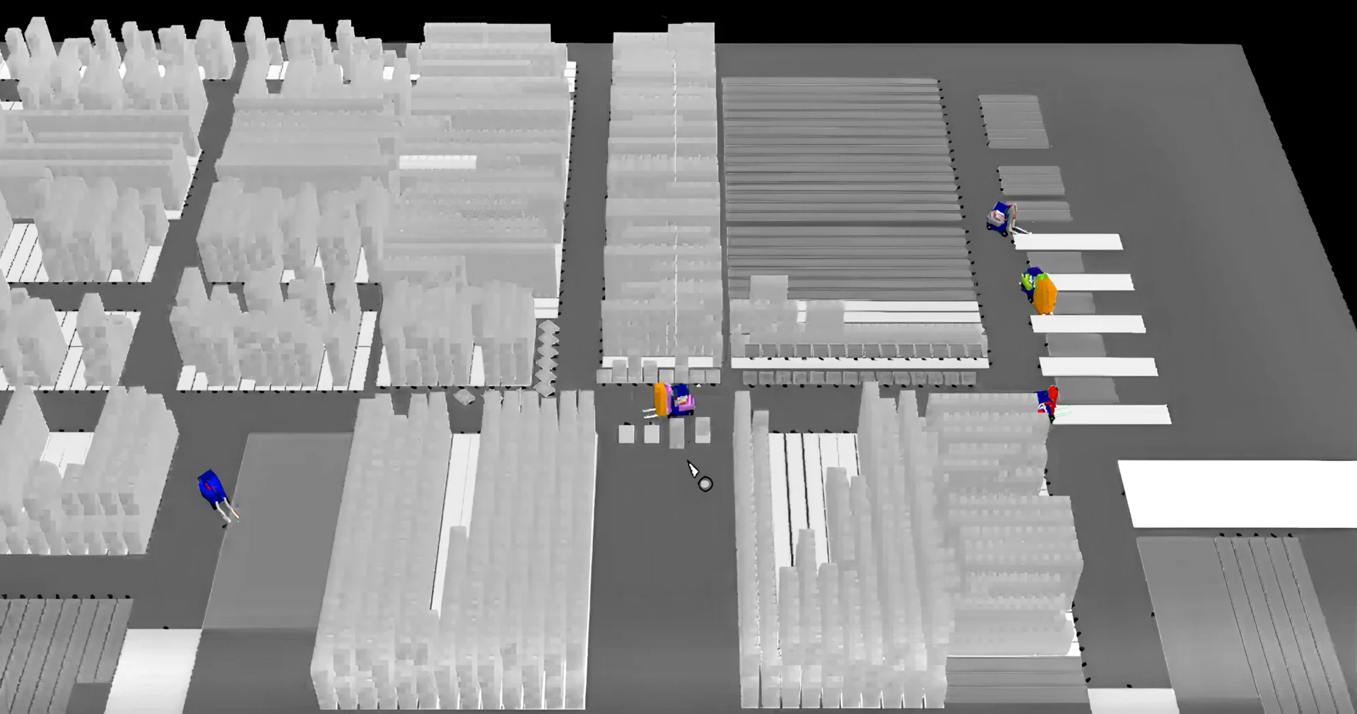
In modern logistics facilities, RTLS provides the supervisory system with real-time coordinates of assets, enabling mission optimization and graphical assistance systems for operators and forklift drivers.
In other words, RTLS is the system that feeds the (intelligent) navigation systems used in the most advanced plants, benefiting all involved operators. Applications based on RTLS usually provide a consumer-style interface (similar to everyday navigation apps) and are designed for mobile devices: handheld terminals and smartphones for pedestrian routes, and tablets for material-handling vehicles. RTLS technologies are also the foundation of automated material-handling systems such as AGVs.
Thanks to real-time location, the dispatching system can automatically assign missions to the closest vehicles and calculate optimal routes, eliminating idle time and reducing congestion in aisles. The Forklift Guidance System (FGS) continuously receives precise coordinates of forklifts and obstacles, providing operators with immediate visual instructions on onboard displays (just like a GPS navigator) and automatically optimizing warehouse flows based on the actual position of all assets.
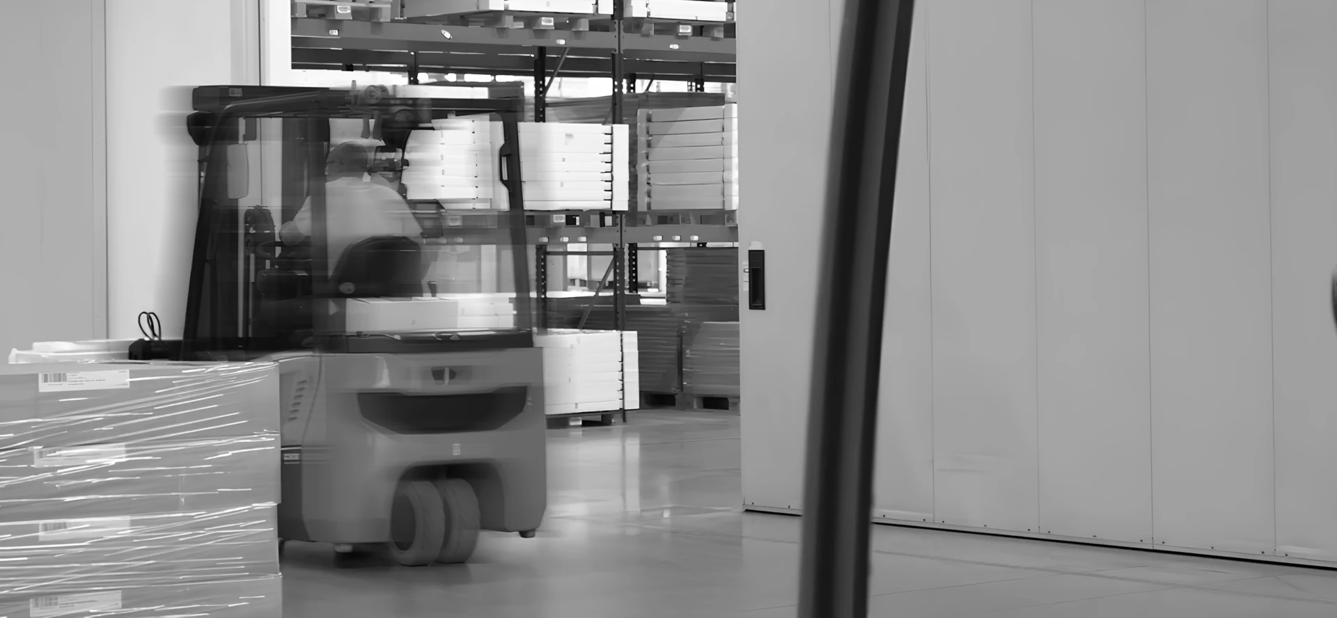
Here is a video example of guided movements in a warehouse using RTLS technology and a Forklift Guidance System (FGS):
It is important to note that RTLS does not identify a single technology, but rather a family of different real-time locating solutions. Each company has different requirements, and these determine:
- the choice of the most suitable technology (active or passive RFID, UWB, BLE, GPS, etc.);
- the desired level of accuracy;
- the available budget (in terms of implementation and operation).
For example:
- If the goal is simply to know whether an object has passed through a specific point, passive RFID tags may be sufficient.
- If highly accurate localization (within meters or centimeters) is required, for example, to avoid forklift collisions or locate a specific load unit in a large and dense area, more advanced technologies such as UWB (Ultra-Wideband) or hybrid systems are used.
In short, not all warehouses need the same RTLS solution. Customizing the technology based on the type of activity, layout, goods handled, and level of automation is essential to achieve a real return on investment.
Energy efficiency and waste reduction: RTLS as a key ally
RTLS makes logistics flows more sustainable and supports corporate ESG goals. By providing the real-time position of vehicles and operators, it enables the dispatching functions of WMS or WCS systems to intelligently combine missions according to the actual warehouse situation. The result is a significant reduction in empty trips, travel distances, and energy consumption. Fewer unnecessary movements mean lower emissions, less waste, and more efficient logistics.
Technology benefiting warehouse operators
Thanks to RTLS, operators work with less effort and greater safety. In many contexts, they no longer need to get off the forklift to manually read codes, while assisted vehicle guidance (FGS) enables functions such as anti-collision alerts directly on the onboard terminal. This provides concrete support that reduces risks and improves work quality in a true human–machine symbiosis.
But is it true that RTLS systems allow precise control over who does what in the warehouse? Fortunately not. RTLS systems are not designed to spy on operators: they only monitor mission progress and the position of vehicles or load units. Information about individual workers is anonymized, ensuring privacy is respected at all times.
RTLS: available technologies and how to choose the right one
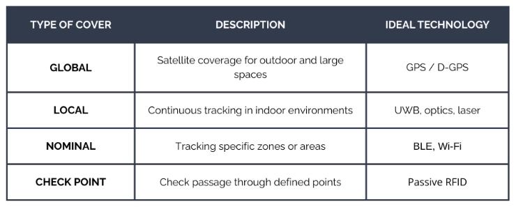
When discussing RTLS (Real Time Location System), it is important to understand that several localization technologies exist, each with different characteristics, costs, and accuracy levels. The choice depends on factors such as the environment (indoor/outdoor), required precision, detection frequency, and available budget.
A complete RTLS system typically consists of three main components:
- Tags or transponders (also called beacons, active or passive): attached to objects or worn by people and vehicles.
- Receivers (readers, gateways, or position sensors): collect data from tags and send it to the system.
- Localization software: processes the data, calculates positions, and makes them available through applications (e.g. WMS, FGS, middleware, safety systems, supervisory dashboards).
Below are the main localization technologies used in modern RTLS systems, with their pros and cons:
1. GPS and D-GPS (Differential GPS)
- Ideal for outdoor environments, where large-scale coverage is required.
- The D-GPS variant provides greater accuracy and is often used to guide logistics vehicles outdoors.
- Not suitable for indoor environments, since satellite signals do not penetrate buildings effectively.
2. Wi-Fi and Bluetooth Low Energy (BLE)
- Very common and relatively inexpensive active RTLS technologies.
- They provide medium accuracy (around 5 meters), sufficient for some applications but not for high-resolution requirements.
- Excellent for mixed environments and locations where a corporate Wi-Fi network is already in place.
3. Ultra Wideband (UWB)
- A high-precision RTLS technology (typically up to 10–30 cm accuracy), ideal for indoor industrial and logistics contexts.
- It enables real-time monitoring with low latency.
- However, it does not accurately detect the orientation (rotation angle) of vehicles, which can be a limitation in complex environments.
4. Laser technology
- Mainly used in AGV and FGS systems, it enables fast and precise mapping of the environment.
- Highly performant but generally more expensive.
- It has outdoor limitations, as the laser can be affected by sunlight or environmental conditions.
A company in the household retail sector has transformed its warehouse into a concentrate of Industry 4.0 technology, with RTLS systems based on laser technology and advanced safety systems guided by a WMS plant supervisor: discover the Kasanova case study.
5. Optical technology (vision-based RTLS)
- Uses wide-angle cameras installed on vehicles to detect fixed visual markers (e.g., shelves, walls), therefore less suitable for dynamic layouts.
- It offers high precision at relatively low costs, comparable to (or higher than) UWB.
- It is considered one of the most promising solutions for the future evolution of indoor RTLS.
6. Active and passive RFID
- Passive RFID: low cost, excellent for checkpoints and for avoiding manual barcode scanning.
- Active RFID: battery-powered, allows continuous tracking, but involves higher costs and maintenance.
7. Other technologies
- Ultrasound and infrared: once widely used, they are now considered less reliable or outdated compared to other solutions.
- Some systems also adopt hybrid approaches, combining multiple technologies such as UWB + optical or RFID + Wi-Fi, to maximize coverage and minimize costs.
Choosing the right RTLS technology means finding the right balance between required precision, operating environment, available budget, and integration with existing systems. A careful evaluation helps avoid over- or under-sized investments and allows companies to get the most out of their connected warehouse.
From theory to practice: a real-time geolocation RTLS case study
Alpla is an international multinational specialized in plastic packaging, with over 23,000 employees and 190 plants worldwide. For its warehouses, the company uses silwaCAM, the RTLS real-time localization system developed by Stesi, which allows it to make logistics flows more efficient, safer, and more sustainable.
The project began at the Baesweiler production site (Germany) and was later extended to Kaiserslautern, Golborne and Port Sunlight (UK), Dijon (France), Lanseria (South Africa), and Radomsko (Poland). Why does its RTLS work so well? The solution adopted by Alpla includes several features that make it extremely high-performing:
- upward-facing cameras that read suspended QR markers (this avoids the use of floor markers, which are highly subject to wear over time);
- localization accuracy up to 10 cm using optical technology with very low energy consumption;
- elimination of handheld scanners: operators no longer need to leave the forklift to manually scan codes;
- intelligent mission combination, reducing cycle times by up to 25%.
Thanks to this well-designed combination of RTLS technologies and WMS software (Warehouse Management System), Alpla’s warehouses have reduced empty trips, increased operational safety, and improved internal resource management. The absence of lasers, complex infrastructure, or invasive technologies makes the system highly scalable and easily replicable in multi-site environments, also contributing to the company’s sustainability goals. Furthermore, the Radomsko plant in Poland successfully adopted an outdoor RTLS solution for flows outside the warehouse, taking safety and efficiency beyond expectations.
Conclusions: some data about Real-Time Locating Systems
The evolution of RTLS systems over the past decade tells a story of continuous innovation and digital transformation. As explained by Stefano Cudicio, President of Stesi and Professor of Business Information Systems at the University of Udine: “Around 2012, when we introduced the first assisted guidance systems at Stesi, it was not possible in Italy to uniquely identify a handling unit in an open logistics space without scanning barcodes, and there was no system for assisted guidance of material handling vehicles.”
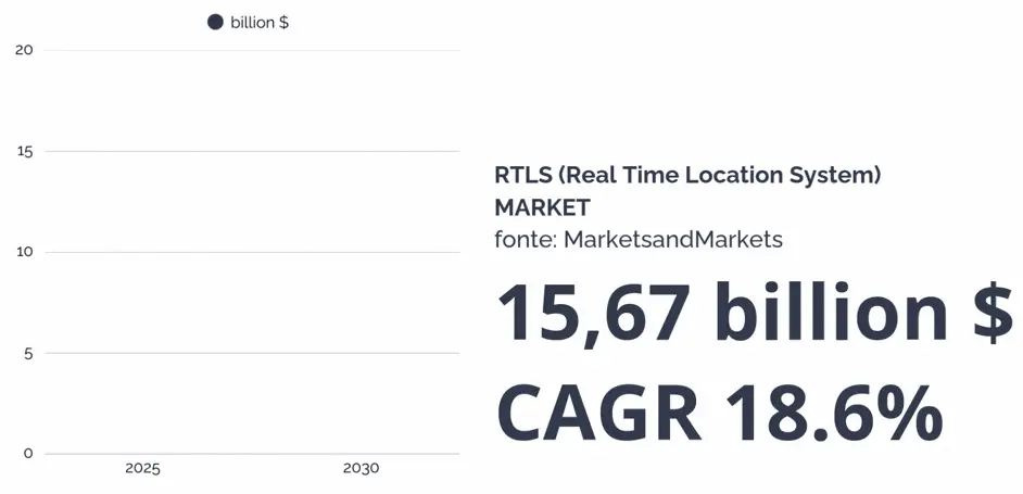
Today, more than a decade after those early experiments, RTLS systems have become a fundamental pillar of Logistics 4.0. According to MarketsandMarkets, the global RTLS market is expanding rapidly: it is expected to grow from USD 6.68 billion in 2025 to approximately USD 15.67 billion by 2030, with a compound annual growth rate (CAGR) of 18.6%. Leading sectors include healthcare, manufacturing, retail, supply chain, and many others where real-time tracking not only optimizes resource utilization but also ensures high safety standards.
As Cudicio emphasizes: “Being able to identify handling units without scanning barcodes would allow us to calculate optimal routes and the best combination of all transport missions. In addition, we wanted to provide operators with visual indications of the route to follow and real-time guidance.”
What seemed like an ambitious goal in 2012 is now a consolidated reality, although the technological complexity requires specialized expertise for successful implementation. Discover silwaCAM, Stesi’s RTLS system and the first Italian solution to implement assisted vehicle guidance through geolocation.

FAQ: Frequently Asked Questions about Real-Time Locating Systems
What is the difference between indoor RTLS and outdoor RTLS?
Indoor and outdoor RTLS systems use different technologies depending on the environment. Outdoor RTLS mainly relies on GPS and D-GPS to track vehicles and goods in open spaces such as yards, port terminals, and external logistics hubs, ensuring large-scale coverage. Indoor RTLS, on the other hand, uses technologies such as UWB, BLE, Wi-Fi, laser, and optical systems to precisely locate assets and people inside warehouses, factories, and distribution centers, where GPS signals do not penetrate effectively.
Which industries benefit most from RTLS systems?
Industries that benefit most from RTLS implementation include: healthcare (tracking patients and medical equipment), manufacturing (monitoring production and assets), retail and e-commerce (optimizing picking and inventory), automotive (supply chain management), pharmaceutical (drug traceability), food & beverage (cold chain monitoring), port logistics (container tracking).
Is Artificial Intelligence used in RTLS systems?
The most advanced vehicle geolocation systems can use Artificial Intelligence, particularly neural networks trained to recognize fiducial markers. Established companies such as Alpla, Ideal Standard, and EuroCarta already use these systems. Learn more about Artificial Intelligence in logistics.
How can RTLS be integrated with existing warehouse management systems?
RTLS can be integrated with existing WMS software through APIs or middleware, allowing real-time RTLS device data to be connected to the management system. If you are looking for the solution that best meets your geolocation needs, book a free initial check-up with Stesi. By getting to know your processes, we can guide you toward the best way to secure and optimize your warehouse.